

Archive Record
Images
Metadata
Collection |
Morlatton |
Archive Number |
MVFN1 |
Title |
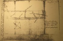
"A Draught of The Three Last Courses of Oaley [sic] Road To Thomas Miller’s [Sic, Millard’s] Mill" |
Description |
A copy from MICROFILM, by The Historical Society of Pennsylvania: A 1719 map entitled "A Draught of The Three Last Courses of Oaley [sic] Road To Thomas Miller’s [Sic, Millard’s] Mill", from the public records of the Court of Quarter Sessions of Philadelphia County. This survery "Draught" provides an abundance of historical and topographical details on sites and structures in the Manatawny region [the territory northeast of the Schuylkill River ranging from the French Creek to the site of present-day Reading, later the smaller tract between the Manatawny and Monocacy Creeks on the banks of the Schuylkill] in the first quarter of the 18th century: 1. The approximate and correlative locations of the houses of Mouns Jones, Andrew Lycons, and "Marcus Hulyns" [sometimes called "Huling's" house, which by about 1730 functioned as the first licensed "Publick" House in Manatawny, later the "White Horse Tavern", which in about 1763-5 was relocated slightly northward to the extant stone tavern building on the "Main Road"]. 2. Thomas Millard’s Mill on the opposite river bank about a quarter of a mile down-river from Mouns Jones’s house; 3. The Manatawny segment of the "Main Road to Philadelphia"{a} and its compass readings; {a} This roadway nomenclature indicates that a passable road connected the small Manatawny settlement to Philadelphia, the primary port and commercial center in the mid-Atlantic colonies, by 1719, probably a few years earlier, in response to the 1715 Petition requesting a road to the "Plantations" of Mouns Jones and his neighbors. This "Main Road" land-corridor was critical to the fur trade and general mercantile enterprise conducted by Mouns Jones under an Indian Trader License from William Penn through his agent James Logan. Jones was a holder of a License by 1717 and traded on his own account and in partnership with Anthony Sadowski [Logan Journals, Historical Society of Pennsylvania]. The transactions recorded in the Logan Ledgers in this period between Logan and Mouns Jones and his son Peter, sometimes including the "Manatawny Polander" Sadowski as their partner, indicate that the Manatawny traders were hauling [also "Hawling" or "waggoning"] large quantities of consumer and Indian Trade goods by wagon in exchange for furs acquired from the Native Americans, over the "Main Road" delineated on this Draught. 4. The "Oaley [sic] Road, the main artery for the transport of grain and other crops from the fertile Oley Valley to Millard’s mill and to the road systems through Montgomery and Chester Counties to Philadelphia. 5. The compass Bearing of the last course of the Oaley Road to the ford crossing to Millard’s mill; 6. The approximate compass alignment of the Schuylkill River. Laurence Ward, June 2016 |
Date |
1719 |
Object Name |
Map |
Catalog Number |
1003.01.10 |
Search Terms |
Court of Quarter Sessions of Philadelphia County draught Historical Society of Pennsylvania Indian Trader License map microfilm mill Millard's Mill Oaley Oaley Road Oley Philadelphia Philadelphia County Road Survery |
People |
Court of Quarter Sessions of Philadelphia County Historical Society of Pennsylvania Huling, Marcus Hulyns, Marcus Logan, James Lycon, Andrew Millard, Thomas Miller, Thomas Sadowski, Anthony |
Condition |
Not Rated |
Condition Notes |
PHOTOCOPY |
Archival History |
Microfilm (conducted by The Pennsylvania Historical Society, Phil., PA) |